Part
01
of two
Part
01
Why are there more natural disasters in the US compared to other countries?
Key Takeaways
- According to a report from Statista, the United States experienced a total of 43 major natural disasters in the year 2021, which was by far the highest number reported globally.
- Sean Potter, who is an NYC-based weather historian and meteorologist, states, "The contrast of cold, dry, Arctic air from Canada and warm, moist, tropical air from the Gulf of Mexico, Pacific and Atlantic help fuel the massive storms that move across the country year-round, bringing everything from blizzards to heavy rain and thunderstorms, depending on the time of year."
- North America lacks an east-west mountain range, which means there are no structures to block cold winds traveling from the north that eventually collide with warm weather in the south, leading to weather extremes.
- In the United States, low-pressure systems typically extract cool and dry air from the High Desert (southwest) or the Rocky Mountains, while extracting the humid and warm air from the Gulf of Mexico. Those areas that lie in between these regions then become the perfect breeding ground for severe weather. Furthermore, almost one-third of the United States consists of the Mississippi River valley and the Great Plains, croplands and grasslands that rapidly heat up and develop "pockets of rising warm air."
Introduction
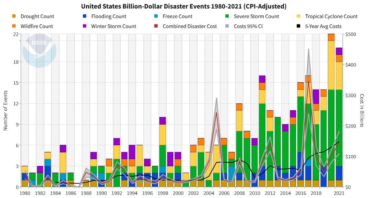
The United States experiences more major natural disasters than any country in the world, including a total of 20 different billion-dollar disasters taking place in 2021. Most of these natural disasters are classified as severe storms or tropical cyclones. From 1980 to 2021, natural disasters cost the United States approximately $2.5 trillion in damage, with billion-dollar disasters accounting for $2.15 trillion of this total. Some of the reasons why the country is more prone to natural disasters are its geographic diversity/makeup of the United States, the climate/atmospheric conditions in states located in the Midwest, South, and the Plains, and the effects of climate change. Additional details on this topic have been presented below.
The U.S. Has the Highest Number of Disasters
- According to a report from Statista, the United States experienced a total of 43 major natural disasters in the year 2021, which was by far the highest number reported globally. Indonesia was second, having reported 28 natural disasters in 2021, followed by India and China with around 19 and 17 respectively.
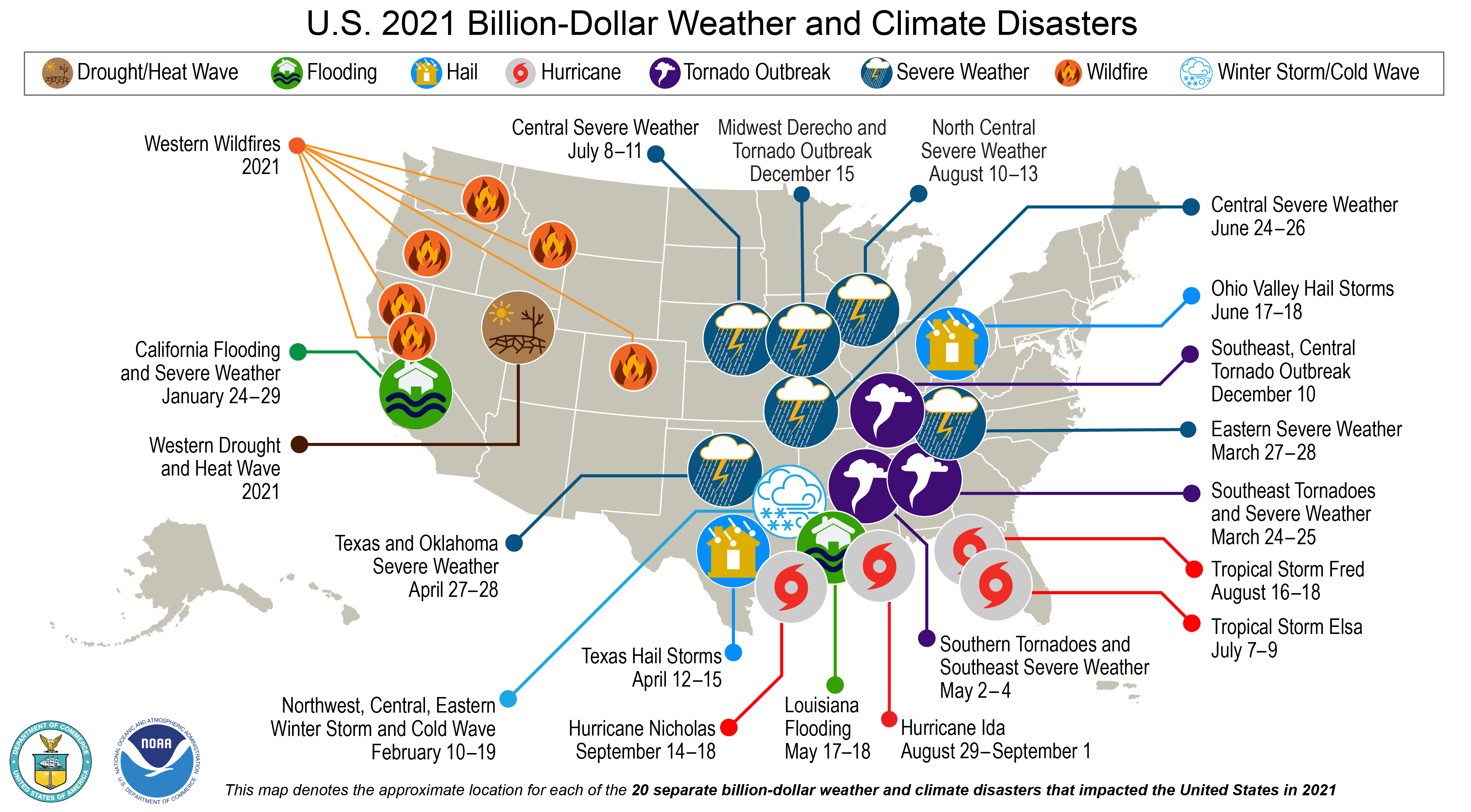
- Over 2,000 natural disasters have been recorded in the United States over the last seven decades, according to World Atlas. The 20 different billion-dollar disasters (those causing in excess of $1 billion in damage) in 2021 alone accounted for more than $152.6 billion in costs. Indirect and direct fatalities from these billion-dollar disasters amounted to at least 724 in 2021, which was twice as large as the number reported for the previous year and the sixth largest on record.
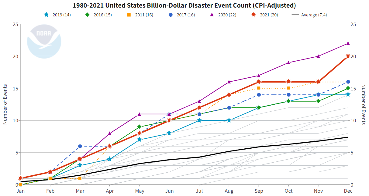
- The majority of these major natural disasters reported in the United States in 2021 were severe storms, followed by tropical cyclones. Also, billion-dollar natural events have accounted for $2.15 trillion of the $2.5 trillion (or 85%) in disaster-related costs in the United States from 1980-2021.
Reasons
1. Geographic Makeup/Diversity
- One of the primary reasons why the United States experiences the highest number of natural disasters is the geographic makeup/diversity of the country, which indicates that some areas of the country are more prone to certain types of natural disasters when compared to others. Each of the nation's geographic regions experiences "a unique combination of weather and climate hazards", as reported by the National Centers for Environmental Information (NCEI).
- The country is positioned between two separate oceans and the mid-latitudes, meaning that the nation is situated between the North Pole and the equator. Sean Potter, who is an NYC-based weather historian and meteorologist, states, "The contrast of cold, dry, Arctic air from Canada and warm, moist, tropical air from the Gulf of Mexico, Pacific and Atlantic help fuel the massive storms that move across the country year-round, bringing everything from blizzards to heavy rain and thunderstorms, depending on the time of year."
- Moreover, North America lacks an east-west mountain range, which means there are no structures to block cold winds traveling from the north that eventually collide with warm weather in the south, leading to weather extremes.
- All regions of the United States are at some degree of risk from severe storms and tornadoes. Interestingly, the country reports between 80% and 90% of all of the planet's tornadoes.
- In states in the Southwest and near the Pacific Coast, citizens are affected by hurricanes and tropical storms forming in the eastern Pacific Ocean, the Caribbean Sea, the southern Atlantic Ocean, and the Gulf of Mexico. While floods can occur anywhere throughout the United States, states in coastal areas are more prone to them due to the impact of the hurricane season.
- Similarly, earthquakes can take place in any state. However, those near active fault lines, such as the states of California, Nevada, Washington, and Hawaii, have a higher frequency of this particular natural disaster.
- To illustrate the geographic breakdown described above, in 2021, billion-dollar natural disasters that the United States experienced included eight severe weather events, four tropical cyclones, three tornado outbreaks, two flood events (in Louisiana and California), one winter storm/cold wave (in Texas and the deep south), one wildfire "event" (wildfires reported across seven different states), and one drought/heatwave event (in the western portion of the country).
2. Climate/Atmosphere of Southern and Midwest States
- Another reason why the United States reports more natural disasters than other nations concerns the climate and atmospheric conditions of the states situated in the Midwest, South, and the Plains.
- In the United States, low-pressure systems typically extract cool and dry air from the High Desert (southwest) or the Rocky Mountains, while extracting the humid and warm air from the Gulf of Mexico. Those areas that lie in between these regions then become the perfect breeding ground for severe weather. Furthermore, almost one-third of the United States consists of the Mississippi River valley and the Great Plains, croplands and grasslands that rapidly heat up and develop "pockets of rising warm air."

- As stated by Dr. Harold Brooks, an NOAA National Severe Storms Laboratory senior scientist, severe thunderstorms that produce tornadoes merely require cool, dry air at between 10,000-30,000 feet and humid, warm air close to the ground, along with horizontal winds.
- Referring to the uniqueness of the topography and atmospheric conditions in southern states, Dr. Brooks goes on to state, "No place else in the world has the large warm water on its equatorward side with a wide high range of mountains extending from north to south to the west of it."
- As a result, the United States experiences twice as many thunderstorms as Europe. It also recorded a much larger yearly average tornado count from 2011-2020 (1,173 vs. 256) despite being similar in size.

3. Climate Change
- Finally, researchers believe that climate change and human-caused global warming have helped to exacerbate the frequency and severity of natural disasters in the United States and worldwide, although this belief is not universal. Climate change is actively impacting regional temperatures in the country and is expected to worsen the impact of such disasters.
- Moreover, human-caused global warming has caused a rise in sea surface temperatures in the Atlantic, which much of the East Coast is exposed to, along with causing atmospheric circulation shifts that encourage the formation of tropical cyclones.

- In their research study titled Tropical Cyclone Frequency Under Varying SSTs in Aquaplanet Simulations (published in February 2021), hurricane scientist Adam C. Burnett, along with three colleagues, found that Intertropical Convergence Zones (ITCZ), which are globe-encircling heavy thunderstorms, are shifting poleward, increasing the volume of named storms in the Atlantic. The study acknowledges the possibility that human-caused global warming has caused such shifts.
- The frequency of natural disasters can be connected to climate change, according to Paul Ullrich, a UC Davis associate professor of regional climate modeling. Increased intensity of land-falling storms in the United States over the years has resulted in greater precipitation, and warmer air can hold additional water vapor, leading to extreme precipitation events (e.g., hurricanes and tornadoes). In turn, these developments lead to greater precipitation themselves, causing floods.
- Additionally, some states have endured stronger summertime drying due to hotter temperatures recorded during the summer season, mixed with the melting of snowpacks in the Upland forests and the Sierra Nevada. In California, there has been an erosion of 20%-30% of natural mountain snowpack over the past five decades because of climate change, resulting in drier conditions because of the limited amount of snow. This has caused forests to dry and increased the likelihood of wildfires.
- In Texas, a stratospheric sudden warming event recently enabled Arctic air to escape from the Arctic circle southward and travel to the southern portion of the state. After the air escaped, there was "no correcting factor from the underlying meteorology" that was capable of confining it, leading to a prolonged effect on local weather patterns, most notably a confounding Texas winter in which temperatures fell to 20 degrees in the city of Houston in mid-February (56 degrees is the average temperature during this time).
Research Strategy
To determine why there are more natural disasters in the United States compared to other nations, we leveraged some of the most reputable sources available in the public domain. Our research included government sources focused on climate and natural disasters, such as the National Centers for Environmental Information (NCEI), Climate.gov, etc. We also searched for reports, articles, and press releases discussing the frequency and severity of natural disasters in the United States, in comparison to other nations. We focused on those published by reliable news, media, and press distribution websites, such as the Washington Post, CNN, and USA Today, among others. Furthermore, we used academic sources such as UC Davis, Yale, etc.
Please note that some of the sources used in this brief were published outside of the standard two-year time frame and have been included due to the relevance of the information contained within them. We made sure to only include older sources for data that was not time-sensitive (such as the geographic position of the US) and additionally verified that there were no scientific discoveries that could undermine those findings.
We would also like to clarify that while climate change is also affecting other regions, we decided to include it among the factors as it exacerbates other geographic and atmospheric conditions that make the US more exposed to natural disaster risk, thus likely having a larger impact compared to countries that are more insulated from extreme weather events due to their geography and local climate.
